Cathedral range topo


Scan The World
3,291
visitas
115
descargas
0 comentarios

Cargando comentarios... 
Cathedral range topo
Published 2017-04-07T18:14:09+00:00
9
0
Add to Collection
Descripción
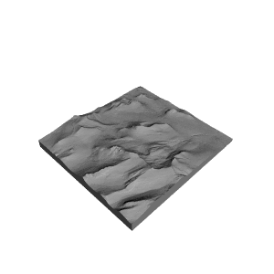
A topo map of the Cathedral range in Yosemite NP. Vertical height is 200% of actual 'cause that's how it feels when you are climbing. Data set is 1/3 arc sec. from the National Map. Kudos to gluetolf for sharing a good technique.
Great for visualizing the Cathedral Traverse route.
Complete instructions on how to make models from digital elevation data can be found on my blog at
Licencia


Detalles de impresión
5.5 hr build on a FlashForm Creator. Sliced in MakerWare. Printed with nasty looking JET ABS. Too bad they don't make more natural looking colors.
You can print it vertical to get a smoother texture, but I prefer the horizontal print because the extrusion lines mimic the contour line on a map.
Información técnica
| Date published | 07/04/2017 |
| Tecnología | FDM |
| Complejidad | Fácil |
Más información
| Titulo | Cathedral range topo |
| Lugar | Yosemite National Park |
Archivos